Fichier:Caspian Sea from orbit.jpg

Fichier d’origine (4 400 × 5 600 pixels, taille du fichier : 3,44 Mio, type MIME : image/jpeg)
Likwé ya mokusé:
| Bolimboli |
العربية: منظرٌ من مدار الأرض لِبحر قزوين. التعليق الأصلي: كما أوردته وكالة الناسا: ::"القسم الشمالي من بحر قزوين يُعاني من ظاهرةٍ تُعرف باسم التخثث أو إغناء الماء، وهي تلك الحالة التي تتسببُ فيها الأسمدة الزراعيَّة المُنسابة من خِلال مياه الري والأمطار بِنُمو الطحالب في المياه. يُؤدي نُفوق وتحلُّل تلك الطحالب إلى حرمان المياه من الأكسجين، ممَّا يُؤدي بِدوره إلى الإضرار بِالحياة البريَّة بِطبيعة الحال. هذه الصُورة لِبحر قزوين تُظهرُ بعض الدوَّامات الخضراء والزرقاء على مقرُبةٍ من مصب نهر الڤولغا (أعلى الوسط)، ممَّا يدُل على وُجود كميَّةٍ من الطحالب. اللون الأزرق اللامع في القسم الشمالي الشرقي من البحر قد يكون تولَّد نتيجة اختلاط بعض النباتات بِالترسُبات، نظرًا لِأنَّ هذا الموقع هو أكثر المناطق ضُحولةً في البحر.
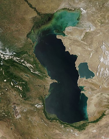
English: This is a view from orbit of the Caspian Sea as imaged by the MODIS sensor on the Terra satellite. Caption: The original caption from NASA: ::"The northern part of the Caspian Sea is plagued by a process called eutrophication, in which agricultural run-off rich in fertilizers stimulates rampant growth of algae in the water. The death and decay of these algae robs the water of oxygen, with obvious negative consequences for aquatic life. This image of the Caspian Sea shows swirls of green and blue near the mouth of the Volga River (top center), which indicate the presence of algae. The bright blue color of the northeastern part of the sea may be due to a mixture of plant life and sediment, for this is where the sea is most shallow. This image is from the Moderate Resolution Imaging Spectroradiometer (MODIS) on the Terra satellite on June 11, 2003.
Español: El Mar Caspio visto desde la órbita terrestre
فارسی: تصویر ماهوارهای از دریای خزر
Тоҷикӣ: Тасвири Баҳр Каспӣ аз осмон |
| Mokɔlɔ | |
| Source |
http://visibleearth.nasa.gov/view_rec.php?id=5514
|
| Mokeli | Jeff Schmaltz, MODIS Rapid Response Team, NASA/GSFC |
| Autres versions | Œuvres dérivées de ce fichier : Caspian Sea from orbit-NoRedLines.jpg |
|

|
Cette image a été promue selon les critères des images de valeur, et est considérée comme l’image de plus grande valeur sur Commons dans le domaine : Satellite images of the Caspian Sea. La proposition est consultable sur Commons:Valued image candidates/Caspian Sea from orbit.jpg. |
Conditions d’utilisation
| Ce fichier provient de la NASA. Sauf exception, les documents créés par la NASA ne sont pas soumis à copyright. Pour plus d'informations, voir la politique de copyright de la NASA. | ||
 |
Attention :
|
Mokóló mwa kásá
Cliquer sur une date et heure pour voir le fichier tel qu'il était à ce moment-là.
| Mokɔlɔ mpé ntángo | Miniátilɛ | Dimasió | Mosáleli | Ntembe | |
|---|---|---|---|---|---|
| ya sikáwa | 14 yúni 2010 à 09:16 | | 4 400 × 5 600 (3,44 Mio) | Originalwana | higher res |
| 8 febwáli 2005 à 15:10 |  | 550 × 700 (67 kio) | Pixeltoo | Caspian sea by space Nasa |
Bikangisele bya kásá
La page suivante utilise ce fichier :
Usage global du fichier
Les autres wikis suivants utilisent ce fichier :
- Utilisation sur af.wikipedia.org
- Utilisation sur als.wikipedia.org
- Utilisation sur am.wikipedia.org
- Utilisation sur ang.wikipedia.org
- Utilisation sur an.wikipedia.org
- Utilisation sur arc.wikipedia.org
- Utilisation sur ar.wikipedia.org
- بحر قزوين
- ويكيبيديا:صور مختارة/الفضاء والكون/نظرة إلى الخلف
- ويكيبيديا:ترشيحات الصور المختارة/بحر قزوين
- ويكيبيديا:صورة اليوم المختارة/ديسمبر 2016
- قالب:صورة اليوم المختارة/2016-12-23
- مستخدم:قائمة أكبر البحيرات والبحار في المجموعة الشمسية
- ويكيبيديا:صورة اليوم المختارة/يوليو 2020
- قالب:صورة اليوم المختارة/2020-07-16
- ويكيبيديا:صورة اليوم المختارة/يوليو 2023
- قالب:صورة اليوم المختارة/2023-07-26
- Utilisation sur arz.wikipedia.org
- Utilisation sur ast.wikipedia.org
- Utilisation sur as.wikipedia.org
- Utilisation sur av.wikipedia.org
- Utilisation sur azb.wikipedia.org
- Utilisation sur az.wikipedia.org
- Utilisation sur bat-smg.wikipedia.org
- Utilisation sur be.wikipedia.org
- Utilisation sur bg.wikipedia.org
- Utilisation sur bh.wikipedia.org
- Utilisation sur bn.wikipedia.org
- Utilisation sur br.wikipedia.org
- Utilisation sur bs.wikipedia.org
- Utilisation sur bxr.wikipedia.org
- Utilisation sur ca.wikipedia.org
- Utilisation sur ce.wikipedia.org
- Utilisation sur ckb.wikipedia.org
- Utilisation sur co.wikipedia.org
- Utilisation sur cs.wikipedia.org
Voir davantage sur l’utilisation globale de ce fichier.